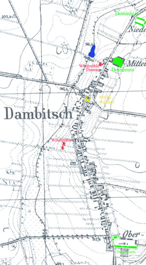
The built-up area of Dambitsch today shows that the former structure of the village being built alongside a road has been largely preserved. This can be drawn from the topograpfical map of 1890, scaled 1:25.000.
Exceptions are the new building areas at the exit road to Lissa, northwestern from the village road in the direction to Neuguth and at the exit road to Reisen as well.
Many old houses were replaced by new buildings or were extended.
The topographical map shows 3 wind mills, one of them is still exisiting near the house Nr. 58. The other 2 near the house Nr. 26 were removed after 1945.
Straw roofed houses e.g. the former houses Nr. 74 and 75 no longer exist.
From the topographical map of 1890 can be drawn that the today’s buildings Nr. 57, 58 and 74 were not yet existing at that date. Indeed building Nr. 58 was erected in 1895.
The map shows 3 former domains: at the village entrance from Reisen (Oberdambitsch), at the village exit to Neuguth (Niederdambitsch) and in the neighbourhood of the windmill (Mitteldambitsch).
Click on the graphic to get an enlarged view. |
|
 |